Governor Ron DeSantis on Monday submitted a proposed congressional map to the Florida Legislature, setting up a Special Session vote this week that could redraw every one of Florida’s 28 congressional districts before the 2026 elections. The map was filed as Senate Bill 8D and is scheduled for a Rules Committee hearing Tuesday and a Senate floor vote Wednesday.
- Advertisement -
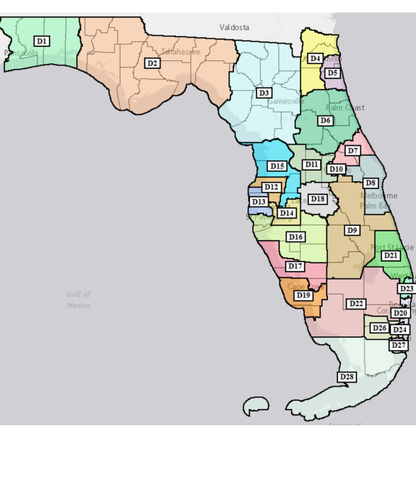
The proposal touches every corner of the state, but for Brevard County the changes are direct and significant. Under the existing map, Florida’s 8th Congressional District includes all of Brevard County, all of Indian River County, and a small portion of east Orange County. Under the proposed map, Indian River County would be removed from the district and the eastern Orange County portion would expand substantially, while Brevard remains whole.
Source: Office of the Governor, Proposed Congressional Redistricting Plan submitted April 27, 2026.
Partisan Composition of the Proposed Map
The version of the map that the Governor’s Office distributed to national news outlets Monday morning was color-coded in red and blue and accompanied by a statement projecting that the proposal would produce 24 Republican-leaning districts and four Democratic-leaning districts. The current map, by comparison, has produced 20 Republican and eight Democratic seats, with one seat recently vacated.
- Advertisement -
“Our new map for 2026 makes good on my promise to conduct mid-decade redistricting, and it more fairly represents the makeup of Florida today,” DeSantis said in a statement to Fox News, which received the map first. The Governor’s Office cited a 1.5 million voter registration advantage for Republicans over Democrats statewide as justification for the redrawn lines.
The four Democratic incumbents whose seats are most affected by the proposed lines, according to analysis by Cook Political Report senior elections analyst Dave Wasserman, are Representatives Darren Soto of Central Florida, Kathy Castor of the Tampa Bay area, Jared Moskowitz of South Florida, and Debbie Wasserman Schultz of South Florida. Wasserman noted on social media that some of the newly created Republican-leaning districts may not be as safe for the GOP as the Governor’s projections suggest, particularly in a 2026 cycle where the party in the White House traditionally loses House seats.
- Advertisement -
The release of a color-coded partisan map by the Governor’s own office is a notable departure from Florida redistricting practice. Florida’s Constitution, in Section 20(a), prohibits drawing congressional districts “with the intent to favor or disfavor a political party or an incumbent.” Florida legislators have historically avoided releasing maps with red and blue district colors to avoid creating an evidentiary record of partisan intent that could be used in litigation.
National Redistricting Context
The Florida proposal is part of a coast-to-coast mid-decade redistricting fight that began when Texas redrew its congressional map at President Trump’s request in 2025. California voters subsequently approved Proposition 50, which temporarily allowed the state’s Democratic legislature to draw new congressional lines and projected to flip four previously Republican-leaning seats. Virginia voters last week narrowly approved a constitutional amendment enabling Democrats there to redraw their map in a way projected to produce 10 Democratic seats and one Republican seat. Maryland is moving on a similar redrawing.
The Governor’s Office told Fox News that planning for the Florida map began before the Virginia vote and was driven by population growth and the pending U.S. Supreme Court redistricting case rather than by retaliation against Democratic-led states. The original Special Session start date was April 20, but DeSantis postponed it by a week to April 28.
The Legal Argument Behind the Map
The map arrived alongside a legal memorandum from Governor’s Office General Counsel David Axelman that frames the proposal as a deliberate departure from Florida’s existing redistricting framework. The memo argues that the Fair Districts Amendments to the Florida Constitution, passed by voters in 2010, are unconstitutional because they require the Legislature to consider race when drawing district lines.
Specifically, the Governor’s Office contends that Section 20(a) of the Florida Constitution, which prohibits drawing districts that would “diminish” the ability of racial or language minorities to elect representatives of their choice, conflicts with the Equal Protection Clause of the Fourteenth Amendment to the U.S. Constitution. The memo points to the pending U.S. Supreme Court case Louisiana v. Callais, which has been argued twice and re-listed for further argument, as evidence that the Court is preparing to issue a major ruling against race-conscious redistricting.
“The proposed congressional map that EOG now submits does not take race into consideration at all,” Axelman wrote. “Race was neither a predominant factor nor one of many factors. And because race was never considered, the map also makes no attempt to adhere to the race-based requirements of the FDA.”
That position is almost certain to be challenged in court if the map is enacted. The Florida Supreme Court ruled on the existing map in 2025 in Black Voters Matter Capacity Building Institute v. Secretary of State, and any successor map will be tested against the same constitutional framework.
What Changes Statewide
Florida currently has 28 congressional districts, each containing 769,221 residents under the 2020 census target. The Governor’s submission keeps that population target intact but reshapes nearly every district. According to the District Statistical Report attached to the submission, all 28 proposed districts hit the population target with zero deviation, except for District 8, which is one resident below target.
The most significant statewide changes appear in three areas. In northeast Florida, the existing Congressional District 5, which combined Black voters in Duval County with Black voters in Leon and Gadsden counties across more than 200 miles, would be redrawn entirely. The Jacksonville-area districts (proposed D4 and D5) would be reorganized around Duval, Clay, Nassau, and St. Johns counties.
In southeast Florida, the changes are even more pronounced. Proposed District 20, which currently has what the Governor’s memo described as a “claw” shape designed to capture Black voters in Broward County, would be redrawn into a more compact configuration. Proposed District 22 would combine portions of Broward, Collier, Hendry, and Palm Beach counties. The Hispanic-majority districts in Miami-Dade County (proposed D24, D26, D27, and D28) would be reconfigured.
In central Florida, the rapidly growing areas around Orlando, Tampa, and Jacksonville would see district boundaries adjusted to reflect population changes. The Governor’s memo noted that Florida has added nearly 2 million residents since the 2020 census, an 8.9 percent increase, with the heaviest growth concentrated in the outer suburbs of Tampa and Orlando and along the Atlantic coast north of Palm Beach County.
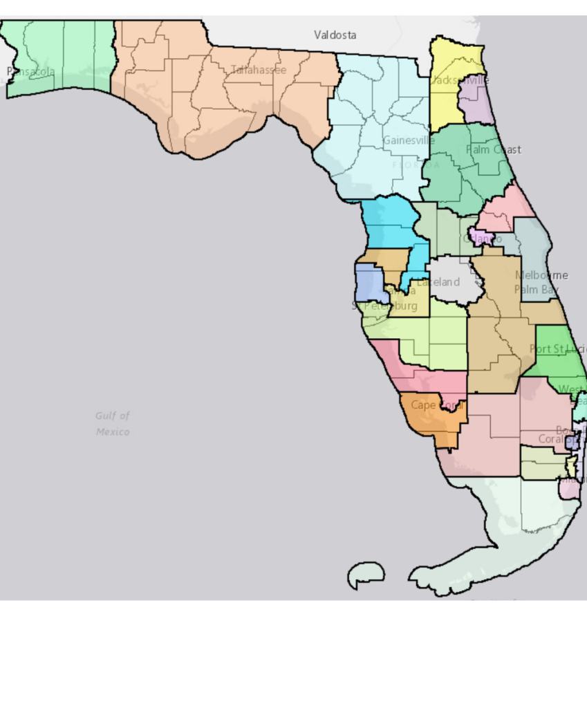
The proposed map shown without district number labels. Source: Office of the Governor.
Compactness and Boundary Compliance
The submission includes a District Compactness Report measuring each proposed district against three standard compactness metrics: the Reock score, the Convex Hull ratio, and the Polsby-Popper score. Higher scores on all three indicate more compact, regular shapes.
Several proposed districts score notably low on compactness. Proposed District 25 in southeast Florida has a Reock score of 0.17 and a Polsby-Popper score of 0.16, both well below typical thresholds for a compact district. Proposed District 28, anchored in Miami-Dade and Monroe counties, scores 0.22 on Reock and 0.24 on Polsby-Popper. Proposed District 4 in the Jacksonville area scores 0.38 on Reock.
By contrast, several proposed districts score very high. Proposed District 27 in Miami-Dade County scores 0.67 on Reock and 0.69 on Polsby-Popper. Proposed District 6 in northeast Florida scores 0.74 on Reock. Proposed District 18 in Polk County scores 0.66 on Reock.
The Boundary Analysis Report shows that most proposed districts follow county lines for a substantial portion of their boundaries. Proposed District 28 follows county lines for 88 percent of its perimeter. Proposed District 2 in the Panhandle follows county lines for 84 percent of its perimeter. Proposed District 8, the new Brevard-anchored district, follows county lines for 86 percent of its perimeter.
What This Means for Brevard County
Detail of the proposed map showing District 8 (right side) anchored by Brevard County and including Melbourne and Palm Bay. Source: Office of the Governor.
Under the proposed map, Brevard County would remain whole within Congressional District 8, but the territory around it would change significantly. The existing District 8 includes all of Brevard, all of Indian River County, and a small portion of eastern Orange County containing communities such as Bithlo, Christmas, and Wedgefield. The proposed District 8 removes Indian River County entirely and expands the eastern Orange County portion to 162,608 residents.
Indian River County, which is currently in District 8 along with Brevard, would move to proposed District 9 along with Highlands, Glades, Okeechobee, parts of Osceola, and a small portion of Polk. The 162,608-person Orange County addition consists almost entirely of unincorporated eastern Orange County, with five residents from the City of Orlando included in the assignment, covering the rural and suburban communities east of Orlando proper extending toward the Brevard County line.
The Brevard portion of the new District 8 includes every incorporated city in the county, according to the Assigned District Splits report. Cocoa, Cocoa Beach, Cape Canaveral, Grant-Valkaria, Indialantic, Indian Harbour Beach, Malabar, Melbourne, Melbourne Beach, Melbourne Village, Palm Bay, Palm Shores, Rockledge, Satellite Beach, Titusville, and West Melbourne would all remain in the same congressional district, along with all unincorporated areas of the county.
Brevard residents would represent approximately 79 percent of the new district’s population, with the eastern Orange County portion making up the remaining 21 percent. Under the existing District 8, Brevard residents make up roughly 73 percent of the district population, with Indian River County contributing about 22 percent and the smaller Orange County portion about 5 percent.
Population and District Composition
Component
Population
Share of District
Brevard County (entire county)
606,612
79.0%
Eastern Orange County (unincorporated + 5 Orlando residents)
162,608
21.0%
Proposed District 8 Total
769,220
100%
Source: Assigned District Splits, Proposed Congressional Redistricting Plan, April 27, 2026. Note: District 8 is one resident below the statewide target of 769,221.
Compactness of the New District 8
The proposed District 8 scores 0.44 on the Reock compactness measure, 0.74 on the Convex Hull ratio, and 0.44 on the Polsby-Popper measure. These scores place it in the middle range among the 28 proposed districts. The district covers 1,859 square miles with a perimeter of 230 miles, according to the District Compactness Report.
The Boundary Analysis Report indicates that 86 percent of the district’s perimeter follows county lines, with 5 percent following roads and 42 percent following water boundaries. The district has no city boundaries cut by district lines, reflecting the decision to keep all of Brevard’s incorporated municipalities intact.
Procedural Path Forward
Senate President Ben Albritton issued a memorandum to all senators Monday afternoon confirming that the Governor’s map had been received at 11:15 a.m. and would be filed as Senate Bill 8D. The bill is scheduled for a Rules Committee hearing on Tuesday, where the Governor’s Office will present the map directly to committee members. A Senate floor vote is scheduled for Wednesday, following consideration of Senate Bill 6, the Medical Freedom legislation by Senator Yarborough.
Albritton’s memo noted that any senator wishing to file an amendment must do so in the form of a complete alternative map, and must work directly with Senate redistricting staff member Jay Ferrin to draft any such amendment. “Drafting maps is highly technical and can take a considerable amount of time,” Albritton wrote. “Senators must be present with Mr. Ferrin to direct the drawing of amendments.”
The House is expected to take up the same map under Representative Mike Redondo, chair of the Select Committee on Congressional Redistricting. If both chambers approve the map and the Governor signs it, the new district lines would take effect for the 2026 election cycle, including the August 18 primary and the November 3 general election.
Litigation Outlook
The map is virtually certain to face legal challenges on multiple fronts. The Governor’s submitted memo openly acknowledges that the proposed plan does not comply with the Fair Districts Amendments to the Florida Constitution, and instead argues those amendments are themselves unconstitutional. That argument has not been accepted by the Florida Supreme Court in prior litigation.
The Florida Supreme Court ruled in 2025 in Black Voters Matter Capacity Building Institute v. Secretary of State on challenges to the existing map. Any successor map enacted under the same constitutional framework would face similar challenges. The U.S. Supreme Court’s pending decision in Louisiana v. Callais, which the Governor’s memo cites as a likely landmark ruling, has not yet been issued and may not arrive before the 2026 primary.
A second line of legal challenge will likely focus on partisan intent. Florida’s Constitution at Section 20(a) prohibits drawing districts with “the intent to favor or disfavor a political party or an incumbent.” The Governor’s Office distributing a color-coded partisan map and publicly projecting partisan outcomes provides potential evidence that opponents could cite in court to establish the intent that the constitution forbids. Nick Stephanopoulos, a Harvard law professor and director of strategy at the school’s Election Law Clinic, told Axios before the map’s release that “it seems completely obvious that any redrawing of Florida’s maps right now would have a partisan intent.”
Reporting from Axios suggests the Governor’s strategy may rely on procedural timing rather than legal merit alone. The “Purcell Principle,” named after a 2006 U.S. Supreme Court ruling, generally discourages federal courts from changing election rules close to an election. By rushing the map through the Special Session in April and into effect for the August 18 primary, the proposal could become difficult to block on the timeline available before voting begins, even if a court ultimately finds constitutional defects.
Six of the seven justices on the Florida Supreme Court were appointed by Governor DeSantis, which has prompted some legal observers to question how aggressively the state court will scrutinize a map submitted by his office. The court upheld the existing map in 2025 in a ruling that, according to legal analysts, narrowed the practical reach of the Fair Districts Amendments.
For Brevard County voters, the practical effect of the proposed map, if enacted and upheld, would be a District 8 that drops Indian River County to the south and expands westward into eastern Orange County. Brevard’s representation as the dominant population center of District 8 would grow from roughly 73 percent of the district to roughly 79 percent. Whether the map will survive both legislative consideration and the litigation that will follow remains to be seen.
The complete proposed map, legal memorandum, district statistical report, compactness report, boundary analysis report, and assigned district splits document can be reviewed through the Florida Senate website at flsenate.gov once Senate Bill 8D is officially filed.