

BREVARD COUNTY, Fla. – The National Hurricane Center is tracking a single disturbance in the Atlantic this morning, and forecasters say it poses no threat to Florida.

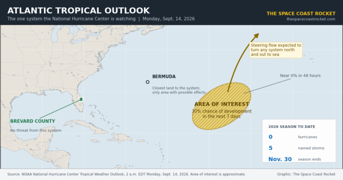
In its Tropical Weather Outlook issued at 2 a.m. EDT Monday, the Miami-based center said a trough of low pressure more than 1,000 miles east-southeast of Bermuda continues to produce disorganized showers and thunderstorms. Strong upper-level winds are tearing the system apart for now, but forecasters expect it to drift into a friendlier environment by the middle to end of the week.
The odds of it becoming a tropical depression or storm in the next 48 hours are near zero. Over seven days, the Hurricane Center puts the chance at 30 percent.
If it does organize, it would be named Fay, the sixth named storm of the 2026 Atlantic hurricane season.
Why it is not coming toward Florida
Forecasters say a series of troughs rolling off the U.S. East Coast should block any developing system from turning back toward the Lower 48. Bermuda is the closest land in the storm’s path and the only place likely to see any effects at all, according to forecast discussions reported over the weekend.

Computer guidance is not in agreement on whether the system ever gets its act together. Newer artificial intelligence models have been more aggressive about developing it than the traditional operational models forecasters have leaned on for decades. That split is one reason the Hurricane Center is holding the number at 30 percent rather than raising it.
A season with no hurricanes at all
The bigger story this month is what has not happened.
The Atlantic has not produced a single hurricane in 2026. Five named storms have formed, Arthur, Bertha, Cristobal, Dolly and Edouard, and every one of them topped out as a tropical storm. Edouard weakened to a remnant low earlier this month, leaving the basin empty.
That puts this season in the record book. The latest first hurricane ever recorded in the satellite era came on Sept. 11, a mark shared by Gustav in 2002 and Humberto in 2013, as Fox Weather reported earlier this month. The 2026 season passed that date with nothing on the map.
By mid-September, an average Atlantic season has produced roughly eight named storms and three hurricanes. This one has produced five and none. If nothing else forms before the season closes on Nov. 30, 2026 would go down as the quietest Atlantic hurricane season of the satellite era and the second quietest since the 1800s.
El Nino is doing the work
Forecasters point to one main cause: a strengthening El Nino in the Pacific, which cranks up wind shear over the tropical Atlantic and shreds storms before they can stack up.
“El Nino increases vertical wind shear over the tropical Atlantic, with the strongest signal over the Caribbean,” NOAA lead seasonal hurricane forecaster Matthew Rosencrans said in comments to ABC News.
NOAA now puts the odds at 75 percent that this El Nino becomes historic between October and December, potentially the strongest such event since at least 1950. It already ranks second strongest on record for this stretch of the year, behind only 1997.
The flip side is playing out in the Pacific, which has run 14 named storms and five hurricanes, ahead of its own average.
NOAA saw it coming, though not to this degree. The agency’s May outlook called for eight to 14 named storms and three to six hurricanes. On Aug. 6 it lowered those numbers to seven to 13 named storms, two to six hurricanes and no more than two major hurricanes. Colorado State University cut its July forecast to nine named storms, four hurricanes and one major hurricane.
What is left of the season
Climatology says the Atlantic is not finished. Roughly 60 percent of all Atlantic tropical activity occurs after Sept. 10, and Florida has learned twice in recent memory what a late-season system can do. Hurricane Helene came ashore in the Big Bend in late September 2024. Hurricane Milton crossed the peninsula in early October 2024.
Andy Hazelton, an associate scientist at the University of Miami’s Cooperative Institute for Marine and Atmospheric Studies, told ABC News that forecasters should “stay vigilant in case a system does find a very narrow window.”
National Weather Service Director Ken Graham has urged preparation regardless of what a seasonal forecast says, pointing out that inland rainfall from tropical systems accounts for a large share of the damage they cause.
What it means for Brevard
Nothing on the map right now requires action on the Space Coast. No watches, no warnings, no advisories.
The practical use of a quiet stretch in the middle of September is time. Emergency managers consistently advise using lulls to handle the items that cannot be done in a hurry: getting a roof inspected and repairs scheduled before a storm is named, clearing gutters and downspouts, trimming limbs away from the roofline, checking that shutters and panels still fit and that the hardware is on hand, photographing the house inside and out for insurance purposes, and confirming coverage details and deductibles with an insurance agent.
Brevard County residents can sign up for AlertBrevard notifications through Brevard County Emergency Management and track official forecasts directly at the National Hurricane Center.
The 2026 Atlantic hurricane season ends Nov. 30.
The Space Coast Rocket will update this story if the Hurricane Center raises development odds or begins advisories.
Criminal Defense
Bankruptcy · Evictions
WICKS LAW P.A.
Call or text for
free consult
321-733-2700
Eric Wicks, Esq.
1250 West Eau Gallie Blvd. G
Melbourne, FL 32935
Abogado Wicks habla español