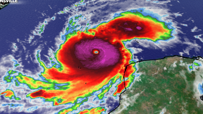
As Hurricane Milton barrels through the Gulf of Mexico, experts are closely monitoring its unprecedented intensity. In just 24 hours, Milton went from a tropical storm, to a category 5 hurricane. With sustained winds over 180 mph and central pressure falling to 897 mb, Milton is nearing the theoretical limits of hurricane strength in Earth’s atmosphere. Hurricane Hunters measured wind speeds up to 216 mph today. These limits, defined by a combination of ocean temperature, atmospheric moisture, and wind shear, are influenced by the natural constraints of physics.


Can Hurricanes Get Stronger?
The strength of a hurricane is determined primarily by the temperature of the ocean, which fuels its power. Warmer seas allow for more intense storms, but there is a cap. The theoretical maximum intensity of a hurricane is a concept meteorologists use to define the most extreme storm a given region could produce under ideal conditions. This limit is based on how much energy can be transferred from the ocean to the storm system, and it is primarily influenced by sea surface temperature and environmental conditions such as humidity and wind patterns. Currently, surface temperatures in the Gulf are exceeding 86°F, providing an abundance of energy for Milton to fuel its rapid intensification.
For comparison, the strongest recorded hurricanes, like 2005’s Hurricane Wilma (882 mb, 185 mph winds) and 1980’s Hurricane Allen (190 mph winds), were close to this limit but never exceeded it. With Hurricane Milton’s central pressure approaching record-low levels and winds reaching 180 mph, it is in similar territory. Climate scientists are observing that as global temperatures rise, these theoretical limits are being tested more often, as warmer seas provide more fuel for storms.
Why Will Milton Weaken Before Landfall?
Despite Milton’s extraordinary strength, forecasters expect the hurricane to weaken slightly before making landfall in Florida. This is typical for strong hurricanes approaching coastal areas due to factors like cooler waters near the coast, interaction with land, and increased wind shear. As hurricanes move closer to land, they often encounter environmental conditions that disrupt their structure and reduce their intensity.
Historically, hurricanes like Hurricane Katrina in 2005 and Hurricane Michael in 2018 showed rapid weakening before making landfall, though they still caused catastrophic damage. Milton is expected to follow a similar path—remaining an extremely dangerous storm but losing some of its peak intensity before striking Florida’s coastline.
How Strong is Too Strong?
The upper limit for hurricane strength is not just theoretical; it’s a balance between the atmosphere’s ability to fuel a storm and the physical constraints that prevent it from becoming even more powerful. Currently, scientists estimate that hurricanes could theoretically reach wind speeds around 200-215 mph under the right conditions, but these would be extreme outliers.
Milton, with its 180 mph winds, is testing the boundaries of what’s possible for hurricanes in this part of the world. If global warming continues to elevate ocean temperatures, we could see storms pushing these boundaries even further in the future.
Timeline for Weakening and Reintensification
Once Hurricane Milton makes landfall, it is expected to lose strength rapidly within the first 12 to 24 hours due to friction with land and loss of warm ocean water as its energy source. However, upon crossing Florida and entering the Atlantic, Milton could reintensify within another 12 to 24 hours, as sea surface temperatures remain warm and favorable for redevelopment. Though it may not reach Category 5 status again, it could still become a potent storm capable of further damage.
Comparative Hurricanes:
- Hurricane Wilma (2005): Lowest pressure recorded in the Atlantic basin at 882 mb, with peak winds of 185 mph.
- Hurricane Allen (1980): One of the few storms to reach 190 mph winds.
- Hurricane Michael (2018): Made landfall with 160 mph winds, rapidly intensifying before landfall.


